Trail Other activity Kerpen (Eifel) - Duitsland - Eifelsteig 07: Kerpen - Gerolstein - Photo

Duitsland - Eifelsteig 07: Kerpen - Gerolstein

 misph
misph

User

© OpenStreetMap contributors
Length
Length
28 km
Max alt
Max alt
571 m
Uphill gradient
Uphill gradient
676 m
Km-Effort
Km-Effort  
37 km
Min alt
Min alt
360 m
Downhill gradient
Downhill gradient
743 m
Boucle
Boucle
No
Creation date :
2017-05-10 00:00:00.0
Updated on :
2017-05-10 00:00:00.0

(0 Reviews)

Other activity
Other activity
7h52
Difficulty : Medium

Scan this QR Code to open this trail in the SityTrail application

FREE GPS app for hiking

Logo SityTrail SityTrail

IGN / Geographical institutes

Download SityTrail from the App Store Download SityTrail from Google Play

Logo SityTrail SityTrail World

The world is yours!

Download SityTrail from the App Store Download SityTrail from Google Play Download SityTrail on Huawei AppGallery

About

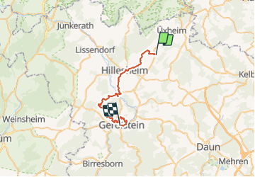
Trail Other activity of 28 km to be discovered at Rhineland-Palatinate, Landkreis Vulkaneifel, Kerpen (Eifel). This trail is proposed by misph.

Description

Duitsland - Eifelsteig 07: Kerpen - Gerolstein

Elevation profile

Positioning

Country:
Germany
Region :
Rhineland-Palatinate
Department/Province :
Landkreis Vulkaneifel
Municipality :
Kerpen (Eifel)
Location:
Unknown
Start:(UTM)
338331 ; 5575548 (32U) N.

Trails nearby

Trail Walking Hillesheim - ESt-09 - Photo
Walking
hubbi

Walking

Medium
Hillesheim, Rhineland-Palatinate, Landkreis Vulkaneifel, Germany
20 km | 28 km-effort
5h 45min
No
Trail Walking Hillesheim - Hillesheim-Gerolstein - Photo
Walking
flip96

Walking

Medium
Hillesheim, Rhineland-Palatinate, Landkreis Vulkaneifel, Germany
26 km | 35 km-effort
6h 0min
No


Close
My subscriptions